Ocean literacy is not merely about understanding the ocean as a physical space—it is about recognizing it as a complex, interconnected system that directly shapes human life. In Indonesia, the world's largest archipelagic nation with over 17,000 islands and 54,000 km of coastline, ocean literacy is a strategic foundation for environmental sustainability and long-term societal resilience.
Indonesia's coastal regions play a critical role in maintaining the balance between terrestrial and marine ecosystems. Yet in recent decades, these areas face compounding environmental pressures: marine debris pollution, declining mangrove coverage, overfishing, coastal erosion, and the accelerating impacts of climate change. These challenges are not only ecological—they directly threaten the social stability and economic livelihoods of the roughly 60% of Indonesia's population who live in coastal zones.
This article introduces a powerful synthesis: combining ocean literacy with five structured strategic intelligence frameworks that help individuals, educators, policymakers, and communities move from passive awareness to deliberate, high-impact action.
What is Ocean Literacy?
Ocean literacy is the understanding of the ocean's influence on you—and your influence on the ocean. Developed by a consortium of U.S. ocean scientists and educators, it is built on seven core principles: the ocean shapes Earth's climate, supports life, influences human well-being, and is largely unexplored. Crucially, it emphasizes that every individual—especially younger generations—has a meaningful role in protecting marine ecosystems through informed awareness and structured, sustained action.
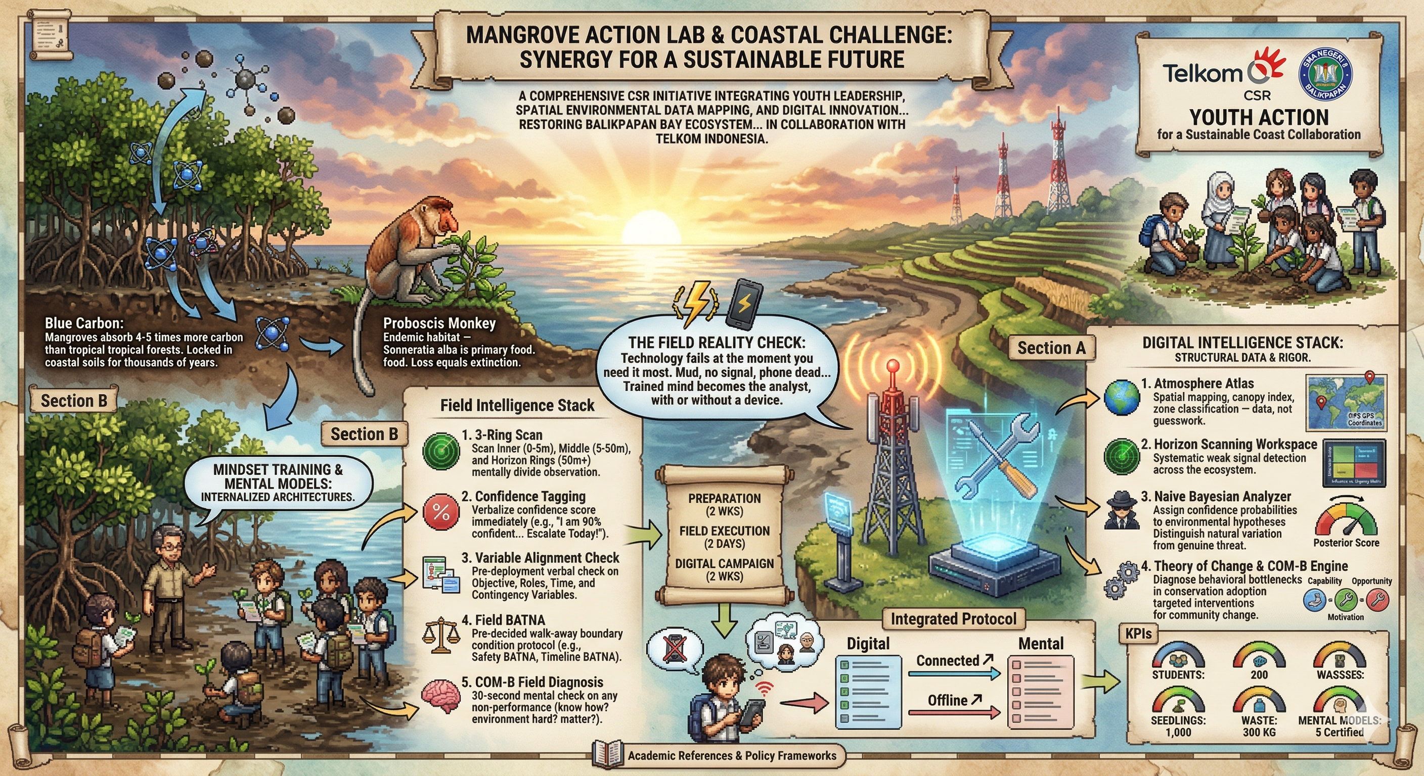
Case Study: Balikpapan Bay, East Kalimantan
Balikpapan Bay is one of the most ecologically significant coastal ecosystems in Borneo. Its vast mangrove forests—spanning thousands of hectares—serve as nurseries for marine species, carbon sinks, and natural storm barriers for the surrounding communities. The bay is also the last known habitat of the endangered proboscis monkey (Nasalis larvatus) in an urban coastal setting.
However, rapid industrialization tied to the nearby oil refinery complex, land conversion for residential development, and the ongoing infrastructure investments connected to Indonesia's new capital city, Nusantara, have placed this ecosystem under unprecedented pressure. Satellite-based remote sensing studies using Landsat and Sentinel-2 imagery have documented a measurable decline in mangrove canopy coverage over the past decade. Without a coordinated, data-informed, multi-stakeholder strategy, this trend risks becoming irreversible within a generation.
The Balikpapan Bay case is not unique—it is a mirror for coastal ecosystem challenges across Southeast Asia. What makes it valuable as a study site is precisely this tension: a globally important ecosystem sitting at the intersection of economic development, climate vulnerability, and civic responsibility.
Why Mangrove Ecosystems Matter
- Coastal protection: Mangrove root systems dissipate up to 66% of wave energy, protecting shorelines from erosion, storm surges, and tsunamis—acting as living seawalls.
- Blue carbon storage: Mangroves store 3–5× more carbon per hectare than tropical rainforests, locking it in both above-ground biomass and deep anaerobic sediments for centuries.
- Marine nursery habitats: Over 75% of commercially important fish and shellfish species in the tropics depend on mangrove systems during juvenile stages.
- Biodiversity hotspots: They provide critical habitat for endemic and endangered species, including the proboscis monkey (Nasalis larvatus), saltwater crocodiles, and hundreds of migratory bird species.
- Economic value: A single hectare of healthy mangrove provides an estimated USD $33,000–$57,000 in ecosystem services annually—including fisheries support, water filtration, and shoreline protection.
Mangroves are not just coastal vegetation—they are irreplaceable natural infrastructure underpinning climate resilience, food security, and human survival in tropical coastlines.
The 5-Framework Model: From Awareness to Architecture
One of the most persistent failures in environmental work is the awareness-action gap: people understand that ecosystems are in danger, yet systemic, coordinated change remains elusive. The five frameworks introduced in this article are specifically designed to close this gap—each targeting a distinct stage of the decision and behavior change process.
Think of them as a pipeline: you detect signals early (Horizon Scanning), reason about uncertainty (Bayesian Logic), map complex system relationships (Variable Planner), evaluate strategic alternatives (BATNA), and finally design behavior interventions (COM-B). Together, they transform environmental literacy into environmental architecture.
Framework 1: Horizon Scanning — Detecting Change Before It Becomes a Crisis
Horizon Scanning is a structured foresight method used by governments, militaries, and international organizations (including the UN Environment Programme and the UK Government Office for Science) to systematically detect early, weak signals of emerging change—before they escalate into full crises.
In the context of coastal ecosystems, horizon scanning means actively monitoring a wide range of environmental and social data streams: satellite imagery showing subtle shifts in mangrove density, changes in fish catch patterns reported by local fishers, increases in coastal debris volumes, policy proposals that could affect land use, and scientific literature flagging new climate models. The goal is not prediction—it is preparedness.
A key tool within horizon scanning is STEEP analysis: systematically reviewing signals across Social, Technological, Economic, Environmental, and Political dimensions. For Balikpapan Bay, a STEEP scan might flag: (S) growing youth environmental activism, (T) new drone-based mangrove mapping technologies, (E) rising demand for blue carbon credits, (E) measurable sea-level rise projections, and (P) new national coastal zoning regulations.
By cataloguing these signals and rating them by probability and impact, decision-makers gain what foresight practitioners call strategic early warning—the ability to act proportionately before small problems become irreversible ones.
Strategic Tool #1
Horizon Scanning Workspace
Map environmental signals across STEEP dimensions, rate them by probability and impact, and generate structured foresight insight from complex coastal ecosystem data. Ideal for teams building early warning systems for environmental governance.
Framework 2: Bayesian Reasoning — Updating Beliefs with Evidence
Environmental decision-making is plagued by uncertainty. Is a sudden spike in mangrove leaf-browning a temporary stress response to a dry season, or the early signature of a fungal pathogen that will spread across the bay? Is the drop in fish catch this season due to natural population cycles, or evidence of long-term overfishing collapse? Acting too early wastes resources; acting too late causes irreversible damage.
Bayesian reasoning offers a mathematically rigorous way to navigate this uncertainty. Named after 18th-century statistician Thomas Bayes, the core idea is elegant: start with a prior belief (your best estimate before new data), collect new evidence, and update your belief proportionally. The output is not a single answer—it is an updated probability that reflects everything you currently know.
In practice, this means a marine biologist can say: "Before seeing the latest satellite data, I estimated a 30% probability that mangrove loss in the northern bay was critically severe. After analyzing the new drone imagery, I now estimate that probability at 72%." That shift in confidence level has direct implications for whether to escalate funding requests, trigger emergency replanting operations, or simply continue monitoring.
Bayesian thinking is particularly powerful for combining multiple imperfect data sources—water quality measurements, community-reported observations, and historical baselines—into a single, coherent picture. It forces decision-makers to be explicit about their assumptions, which makes reasoning transparent and improvable over time.
Strategic Tool #2
Naive Bayesian Analyzer
Input your prior assumptions, add field observation data, and let the engine update your probability estimates in real time. Transform ambiguous environmental signals into concrete, confidence-calibrated insights for high-stakes decisions.
Framework 3: Systems Mapping — Seeing the Whole Web, Not Just the Thread
Coastal sustainability is not governed by a single cause or a single actor. It emerges from a dense web of interacting variables: ecological processes, social behaviors, economic incentives, institutional policies, and technological capacities. Pull one thread and others shift in ways that are often invisible until it is too late.
Systems mapping (also called causal loop diagrams or variable mapping) is the practice of making these hidden relationships visible. It asks: What are all the variables affecting this ecosystem, and how do they influence each other?
For Balikpapan Bay, a systems map might reveal feedback loops like: higher coastal development → less mangrove area → weaker natural wave barriers → more coastal erosion → more development pressure (to relocate eroded communities) → even less mangrove area. This is a reinforcing feedback loop—a vicious cycle that accelerates its own deterioration.
But systems mapping also reveals leverage points: the places in the system where a small intervention produces disproportionately large positive change. Research by systems theorist Donella Meadows identifies 12 leverage points; the most powerful include changing the rules of the system (policies), changing the goals of the system (values), and changing the paradigm—the shared worldview that gives rise to the system in the first place. Ocean literacy directly targets the highest leverage point: changing the paradigm.
When communities can see the whole system—not just their immediate experience of it—they become more effective advocates, planners, and protectors.
Strategic Tool #3
The Variable Planner
Map ecosystem variables, stakeholder relationships, policy dependencies, and causal feedback loops in one unified visual framework. Identify reinforcing cycles, balancing loops, and the highest-leverage intervention points in your coastal system.
Framework 4: BATNA — The Strategic Cost of Doing Nothing
In environmental governance, the most dangerous decision is often not the wrong action—it is inaction disguised as prudence. Delaying mangrove restoration because the costs seem high, or postponing pollution controls because of stakeholder resistance, feels cautious. But when you calculate what you lose by waiting—ecosystem services, carbon storage, fish stock recovery, community health—the true cost of inaction is often staggering.
BATNA (Best Alternative to a Negotiated Agreement) is a concept from Harvard's negotiation framework, originally developed by Roger Fisher and William Ury. In classical negotiation, your BATNA is the best outcome you can achieve if no deal is reached—it defines your "walk away" point. In environmental strategy, we apply it differently: the BATNA becomes a tool for calculating the systemic cost of choosing not to act, and for comparing the value of different intervention pathways.
For example: a local government weighing whether to fund mangrove restoration can use BATNA analysis to compare three scenarios — (A) full restoration investment now, (B) partial low-cost intervention, and (C) no intervention. By quantifying the long-term losses in each scenario (degraded fisheries, increased flood damage, loss of carbon credit revenues, community displacement costs), the analysis often reveals that the cheapest-looking option—doing nothing—is actually the most expensive over a 20-year horizon.
BATNA thinking is also vital for multi-stakeholder negotiations: when an NGO, a government agency, and a private developer disagree on coastal land use, knowing each party's BATNA tells you where there is genuine room for compromise—and where certain parties are bluffing.
Strategic Tool #4
BATNA Leverage Calculator
Define your intervention scenarios, assign long-term cost and benefit values, and calculate the true leverage of acting vs. waiting. Use it to build airtight arguments for environmental investment in negotiations with governments, donors, and corporate partners.
Framework 5: COM-B — Designing Behavior Change That Actually Sticks
Every environmental program eventually runs into the same wall: people know what they should do, but they don't do it. Coastal communities know that dumping waste into mangroves is harmful. Students who join cleanup campaigns rarely sustain the behavior afterward. Awareness campaigns reach thousands but change the actions of very few. This is the behavior change problem—and it requires a behavioral science solution.
The COM-B model, developed by Professor Susan Michie and colleagues at University College London, is one of the most rigorously validated frameworks for understanding and designing behavior change. It proposes that any behavior (B) only occurs when three conditions are simultaneously met:
- Capability (C): The person must have both the physical capability (skills, physical ability, stamina) and psychological capability (knowledge, understanding, cognitive skills) to perform the behavior. In an ocean literacy context: does the community member understand how to plant mangrove propagules correctly? Do students know which waste items are most harmful to coastal ecosystems and why?
- Opportunity (O): The environment must make the behavior physically and socially possible. Physical opportunity means access to tools, materials, safe locations, and time. Social opportunity means cultural norms, peer behaviors, and community expectations that support (rather than undermine) the action. A student cannot replant mangroves if no program gives them access to coastal land. A fisherman will not switch to sustainable gear if no supply chain makes it affordable.
- Motivation (M): The person must want to perform the behavior—either through reflective motivation (conscious goals, personal values, plans) or automatic motivation (emotional responses, habits, impulses). The most durable environmental behaviors are those tied to identity: "I am someone who protects this coastline" is more powerful than "I was told to plant trees."
COM-B is valuable because it forces program designers to diagnose the root cause of behavior gaps before prescribing solutions. If a community isn't protecting mangroves because they lack knowledge (Capability gap), more knowledge campaigns are the answer. But if they lack access to tools (Opportunity gap) or feel that no one else is doing it (Social Opportunity gap), knowledge campaigns will fail—even if they're brilliantly designed.
Programs like the Mangrove Action Lab & Coastal Challenge at SMA Negeri 8 Balikpapan demonstrate how experiential, place-based learning can activate all three COM-B components simultaneously: students gain hands-on capability through field work, opportunity through school-community partnerships, and motivation through direct emotional connection with the ecosystem they are protecting.
Strategic Tool #5
Theory of Change & COM-B Engine
Diagnose which COM-B components are blocking behavior change in your community. Then design a Theory of Change—a structured causal logic that maps your interventions to measurable long-term impact. Built for educators, NGOs, and policymakers designing programs that need to prove results.
Putting It All Together: The 5-Framework Pipeline in Practice
These five frameworks are most powerful when used as an integrated system rather than standalone tools. Here is how they connect in a real coastal conservation workflow:
- 1Horizon Scanning continuously monitors the coastal environment for early signals—new stressors, policy changes, ecological shifts—and feeds them into a structured risk register.
- 2Bayesian Analysis is applied to the most concerning signals, updating confidence levels as new field data arrives and helping teams decide which threats warrant urgent escalation vs. continued monitoring.
- 3Systems Mapping is used to understand the full causal context of the prioritized threat—identifying which variables are driving it, which feedback loops are accelerating it, and where the highest-leverage intervention points lie.
- 4BATNA Analysis is applied to the proposed interventions—calculating the real long-term costs of each scenario (including inaction) to build an evidence-based case for investment and to guide multi-stakeholder negotiations.
- 5COM-B + Theory of Change translates the chosen intervention into a community behavior change program—diagnosing barriers, designing activations for Capability, Opportunity, and Motivation, and mapping the causal pathway from activities to long-term systemic impact.
Key Takeaways
Ocean literacy is strategic, not just educational. Understanding the ocean's systems is the foundation for designing policy, behavior, and infrastructure that keep coastal ecosystems alive.
Mangroves are non-negotiable infrastructure. Their loss triggers cascading failures across fisheries, climate resilience, coastal safety, and community livelihoods.
Foresight prevents crises. Horizon Scanning and Bayesian Reasoning allow us to catch ecosystem degradation early—when intervention is still cheap and reversible.
Systems thinking reveals leverage. Most environmental efforts fail because they target symptoms. Systems mapping reveals the structural causes—and the places where small changes produce large results.
Inaction has a calculable cost. BATNA analysis makes the economic and ecological price of delay concrete—transforming abstract urgency into actionable investment logic.
Behavior change is designable. COM-B + Theory of Change gives educators and NGOs a scientific framework for building programs that convert environmental awareness into lasting, measurable stewardship.
Conclusion: Redesigning Our Relationship with the Ocean
Ocean literacy is not the endpoint—it is the starting point. Understanding that the ocean shapes our climate, our food, our economy, and our identity is necessary but not sufficient. What comes after understanding is the harder work: designing the systems, behaviors, and institutions that allow humanity to thrive in genuine partnership with the sea.
The five frameworks in this article—Horizon Scanning, Bayesian Reasoning, Systems Mapping, BATNA, and COM-B—represent a practical bridge between environmental science and strategic action. They are not theoretical abstractions. They are tools that students in Balikpapan, policymakers in Jakarta, NGOs in Makassar, and communities across the Indonesian archipelago can apply right now to the real coastal challenges they face.
Balikpapan Bay is not lost. The proboscis monkeys still call from its mangrove canopy. The bay still filters the city's water. Its carbon stores still quietly offset what the refinery complex emits. But the window for effective, affordable intervention is finite—and it is closing faster than most people realize.
Because the future of coastal ecosystems will not be determined by what we know—but by what we choose to design, together, starting now.